Welcome to Himalayas


Identity Card

Area: 147,181 km2
Capital: Kathmandu
Number of inhabitants: 29 million
Official language: Nepali
Literacy rate: adults 55%, youth 84%
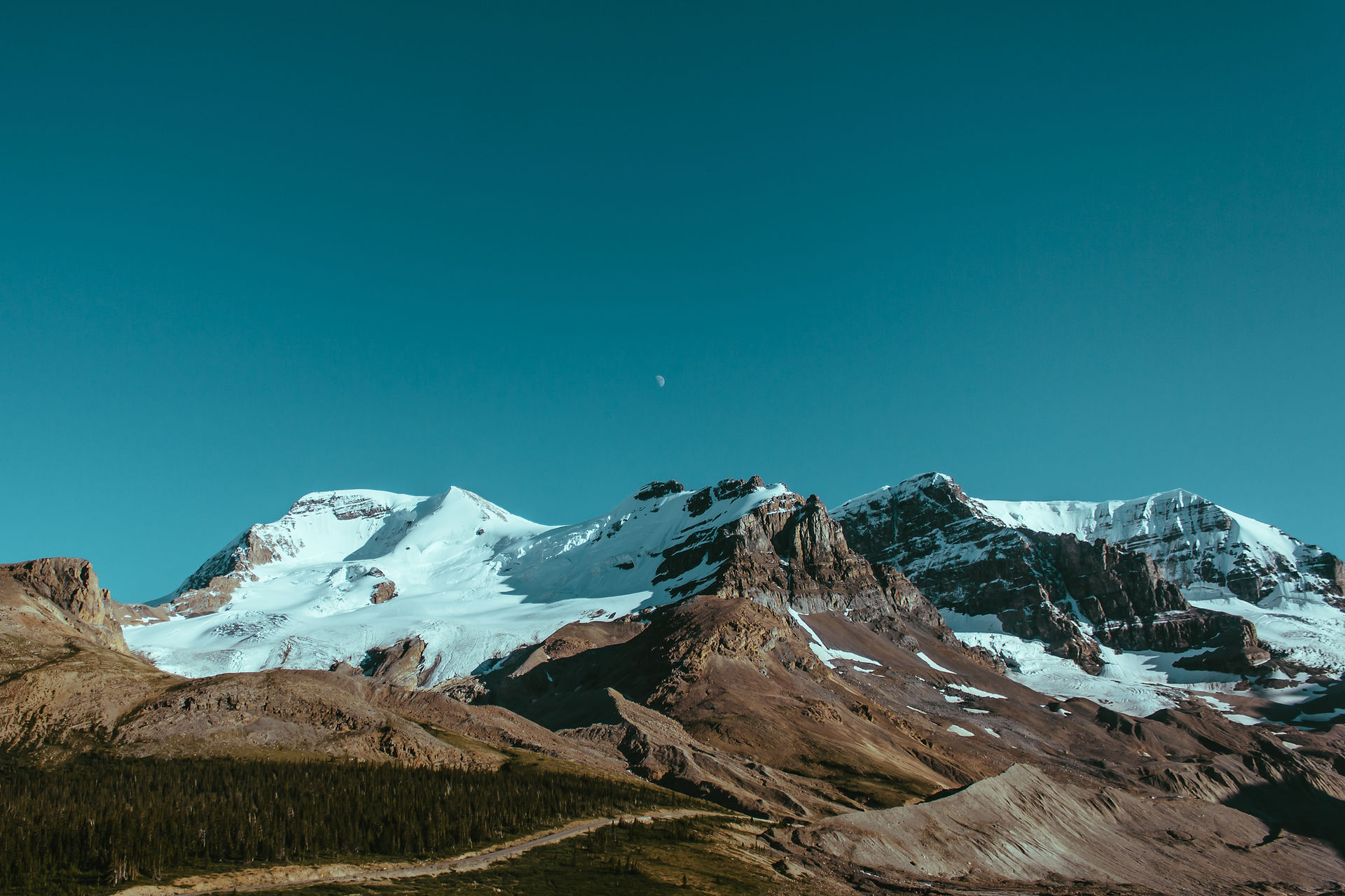
Landlocked country in the Himalayas.
The altitude varies from 60 m to 8,848 m! (Mount Everest)
Population
Nepal is a federal democratic republic.
It is populated by 60 different ethnicities and castes, with more than 30 dialects, where Hinduism and Buddhism are strongly entwined.
It is one of the poorest countries in Asia due to multiple factors: the country's isolation, lack of diversified natural resources and insufficient infrastructure.

Economy
The economy is highly dependent on trade with India, although Nepal is increasingly developing its economic relations with China. Only 20% of the country's surface is cultivable.

Financial resources come mainly from crafts. Nepal is geographically, financially and commercially landlocked. It is one of the least developed countries in the world, it was ranked 145th out of 187 countries in 2015 in terms of the human development index. The country remains very largely rural (82% of the population) although agriculture represents only a third of the GDP.
Nepal also held in 2014 the sad record of second place of the most polluted countries on the planet.
A seismic zone at risk
Following the two earthquakes on April 25 and May 12, 2015, of magnitude 7.8 and 7.4 on Richter scale (causing 9,000 deaths, 15,000 injured and destroying nearly 500,000 houses), the economic situation of Nepal has further deteriorated . This catastrophe is due to the movements of the tectonic plates : the Indian plate passing under the Eurasian plate.
This dynamic created the Himalayan chain and the Tibetan plateau. The Indian plate sinks at a speed of 2 centimeters per year under the Eurasian plate, which causes elevation. The tensions accumulated along this overlap, called "Himalayan mega-overlap", are the cause of many earthquakes, such as that of April 25. Seismologists fear even greater earthquakes in the future. Due to impoverishment, many buildings are made of handcraft bricks and do not meet any earthquake-resistant standard.

Climate

The climate varies : from -15 ° C to 30 ° C depending on the region. Nepal is located in the monsoon zone (June to September), the climate is tropical in the jungles, temperate in the valleys, polar in the high mountains.
Cultural Heritage

4 places are listed as UNESCO heritage :

- Lumbini (birthplace of the historic Buddha),
- The Kathmandu valley, for its historical and artistic Hindu and Buddhist achievements. There are 7 areas of monuments : the Durbar squares, i.e. the urban centers of the three cities of Kathmandu (Hanuman Dhoka), Patan and Bakhtapur with their palaces, temples and public spaces, religious groups of Swayambhu (Buddhist monument, a stupa, the oldest in the valley), Bauddhanath (the largest stupa in Nepal), Pashupati (includes a large Hindu temple) and Changu Narayan (traditional Newar settlements and a Hindu temple complex whith one of the oldest inscriptions in the Valley),
- 2 national parks of Chitwan (last refuge of the Bengal tiger, it also shelters some 450 species of birds) and Sagarmatha (which includes the highest peak in the World, Mount Sagarmatha or Mount Everest, where you can come across the famous snow Leopard).
Nepal has been opening its economy to tourism for a few years. Trekking is booming in the Annapurna massif and Mount Everest, but we also go there for climbing, hiking and to visit and experience temples.
Culinary tradition
The cultural and geographic diversity of Nepal is the source of a variety of cuisines, based on ethnicity , soil type and climate. Primarily vegetarian, Nepalese cuisine is based on the use of rice and lentils. It borrows both Indian and Tibetan culinary traditions, whose influence dates back to the Middle Ages.


Identity Card

Area : 86,904 km2, region of northern India
Largest city : Leh
Number of inhabitants : more than 250,000
Languages used : Hindi (Indo-European language derived from Sanskrit), English, Urdu (Indo-Iranian group), Kashmiri (Indo-Iranian language), Ladakhi (Tibetan-Burmese language)
Literacy rate: adults 69%, youth 86%.
Geographic location
Ladakh is nicknamed "the land of high passes", "Little Tibet" or "Indian Tibet" because of a strong immigration of Tibetan population since the 10th century. With a culture and tradition very close to those of Tibet, Ladakh has long maintained close relations with Tibet, particularly for the wool trade. It is located in the far north of the Indian state, at an average altitude of 3800m in the Himalayan range.


It includes in particular the Indus Valley (the river which gave its name to India). There are the highest roads in the world (Kardung Pass at 5,359m).
Watch out for altitude sickness!
Economy
Ladakh promotes renewable energies for its development (bioclimatic houses, solar energy, permaculture... keeping the spirit of their centuries-old traditions). Ladakh is particularly renowned for its organic cultivation of apricots.

.jpg)
Climate
Unlike the rest of India, this region does not know the monsoon. Despite its mountainous position and heavy snow, it is an arid region where the thermometer fluctuates between -25C° in winter and 30C° in July-August. Snow condemns all road access in winter.

Cultural Heritage

Ladakh is popular for its visits to the many Buddhist monasteries (perhaps over a hundred!). Treks and climbing are becoming increasingly popular, destroying magnificent high-altitude lakes, but these new activities only benefit a few agencies, causing considerable environmental pollution and little improvement in the quality of life for residents.
"Ladakh Buddhist chant : recitation of sacred Buddhist texts in the trans Himalayan region of Ladakh, Jammu and Kashmir, India, was inscribed in 2012 on the Representative List of the "Intangible Cultural Heritage of Humanity" (UNESCO).

Culinary tradition

The food is Indian, spicy, but in remote villages you can taste the traditional "toukpa" (barley flour soup) or be offered a cup of dri butter tea (Yak female) which may possibly be salted. Drinking water is supplied by tanker or by water carriers who pull on their carts cans of more than 20 liters.
The inhabitants have neither running water nor electricity.
Identity Card

Himachal Pradesh literally "Snow-Laden Province", is a state in the northern part of India
Area : 55,673 km2
Number of inhabitants : 6,864,602 inhabitants (in 2011)
Capital : Shimla
Official language : Hindi
Almost 95% of its population is Hindu.
Geographic location
In the heart of the western Himalayas, Himachal Pradesh altitude varies between 450 and 6,000 meters. It is bordered by the Indian states of Jammu and Kashmir to the north, Punjab to the west, Haryana and Uttar Pradesh to the south, Uttarakhand to the southeast and Tibet (region from China) to the east. To the south, the Kangra and Chamba valleys have vast meadows and rolling hills where tea, apple and other fruit trees grow. The state is drained by the Chenab, Ravi, Beas, Sutlej and Yamuna rivers.

Economy

Himachal Pradesh has an important hydraulic network that allows it to supply electricity to the northern states of the country.
The other economic sectors are agriculture and tourism.

Climate
The climate varies depending on the altitude. It can be hot and subtropical in the south and extremely cold in the high mountains of the north and east. There are dry regions and very humid regions.
Generally speaking, there are three successives seasons in Himachal Pradesh : the hot season, the cold season and the monsoon. The rains start at the end of June until August. Winter is harsh from November to mid-March, with frequent snowfall above 2,200 m.

Cultural Heritage

Great Himalayan National Park, a UNESCO World Heritage Site and Pin Valley National Park are the national Parks located in the state. The state also has 30 wildlife sanctuaries and 3 conservation reserves. Leopards, gorals, moschidaes, (the family of moschidae is the family of muscat bearers or improperly musk deer), lophophorus or the Himalayan monal also known as the Impeyan pheasant, is a pheasant native to Himalayan forests. Monkeys like sacred cows are part of the the cities landscape.
Lake Rewalsar or Tsopema is a sacred place of pilgrimage for Buddhists, Hindus and Sikhs. Many temples, some dedicated to Krichna and Shiva (Hinduism), a gurdwara (Sikh place of worship) and Tibetan Buddhist monasteries (Nyingmapa, Kaguypa), adorn the edges of the lake. A huge Padmasambhava Buddha overlooks the lake.

The culinary tradition

Cooking is done with ghee (clarified butter). The staple food is rice frequently accompanied by maahni (dry beans with mangoes) or madra (lentils cooked in yogurt). The diet also consists of potatoes and raves, with more and more green vegetables.